On 3rd November we flew to Rockhampton and joined our share catamaran 'Antidote' for a four week cruise, to include delivering her from Keppel Bay marina to Hope Harbour on the Gold Coast.
Antidote
George is an awesome quartermaster, and we dropped her off in Yeppoon from the taxi to start provisioning, and I went on to carry our gear on board, and pick up a courtesy car from the marina to drive back to pick up George, the food and grog. All went smoothly.
Next morning we sailed over to beautiful Great Keppel Island and started to chill. It had been a busy few weeks before we left, and getting in the sailing groove takes a little while.
With the wind being from the north-east, we had a comfortable night in Monkey Beach.

Great Keppel Island
Sunday Nov 5th we sailed south to Yellow Patch, a sheltered spot in a southeasterly just inside Cape Capricorn. The entrance is tide dependent and unmarked, so we followed waypoints entered by Navionics users.
Since the trip to Fiji, I have been using satellite imagery to navigate, as discussed in another blog entry; OpenCPN with satellite imagery - Generation 2. It is absolutely brilliant, especially when showing fixed hazards like rocks and coral. However when the hazards move, as do sand-banks and mud, the date of the satellite photo is critical. We entered Yellow Patch in good visibility, but you can see how the satellite photo alone would have been misleading.

Yellow Patch

Antidote at Yellow Patch
Tuesday Nov 7th, with the need to pick a tide to escape from Yellow Patch, and a strengthening SE wind, we had a brisk sail round to Sea Hill to position ourselves to transit The Narrows.

The Narrows, between Curtis Island and the mainland, represent an interesting navigational exercise. When there is a brisk SE wind, as we had, to go outside Curtis Island is a rough slog to windward of about 20 nm. The alternative is to go inside, up a narrow channel which dries out at low tide, enough for herding of cows across The Cattle Crossing. For many boats, this requires transit on a day shortly before spring tide, on a rising tide.
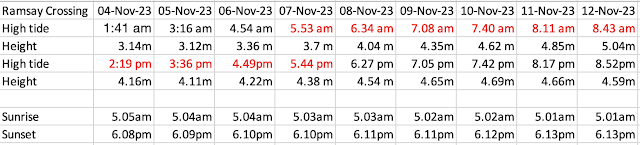
We had some work to get done by a mechanic in Gladstone, which we hoped to occur before the weekend. So we chose to cross the shallows on the Thursday Nov 9th, when high tide occured in daylight, a bit before 7.08am. So we spent Wednesday night at anchorage near Telegraph Creek.


Leads on the north side of the Cattle Crossing

The Cattle Crossing

Back bearing looking behind us

Inline

Plenty of channel markers
Gladstone is a major industrial port, associated with the export of coal from the Galilee basin, and LNG. I have written about it previously, Gladstone's Dark Satanic Mills.

Coal loader

Coal
We needed to stop in the marina to have the engines serviced, the broken tiller arms replaced, and to sort out a problem caused by the local chandlery selling us cheap anchor chain rather than the quality one we had ordered. There was also the small matter of the hose from the holding tank being blocked. 💩
All missions were accomplished, after a fashion.
There is particular problem with boats whose toilets (aka 'heads') are flushed with seawater. The big advantage is that seawater is plentiful and free, whereas freshwater flushing requires bulk desalination. But seawater contains calcium and magnesium salts as well as NaCl salt, and they react with urine to create 'limescale' which is deposited in the hoses and the holding tank. This limescale can block the discharge of paper and poo. It is not a popular job to sort it out, and token efforts and various sorts of quackery abound.

Limescale in the holding tank outflow hose.
It is a complex issue with many opinions. Here is a discussion by ChatGPT which covers some of the principles.
There is a woman in the US who specializes in boat's plumbing who goes by the moniker 'The Head Mistress'. Her comment on prevention is:
'Like most things, prevention is easier than cure...a cupful of undiluted distilled white vinegar flushed through the system weekly, followed after 45-60 minutes by a bowlful of clean fresh water will eliminate the need for cure.'
The tillers broke at some point, likely a late effect of the accident involving the rudders last August. The were welded up, but we arranged for some new stainless steel ones to be made up. They got fitted in Gladstone, hopefully the final chapter of an extended drama.

Broken cast aluminium tiller.

Shiny new stainless tillers
From Gladstone we sailed out to Facing Island, hoping to make a jump out to Lady Musgrave Island on the Great Barrier Reef, but the weather gods were unkind. Strong winds were forecast, which make the reef atolls very unpleasant when waves and tide combine to sweep across the reef. So we pressed on south to Pancake Creek, a favourite anchorage.


Coal ships waiting their turn to be loaded.

Pancake Creek can be entered at any state of tide. It can also be entered at night, but the buoys are unlit. When coming in for the first time at night, the red marks are much further to the right than you might expect.

Pancake Creek

Antidote is third from the left

Bustard Head lighthouse

Clews Point
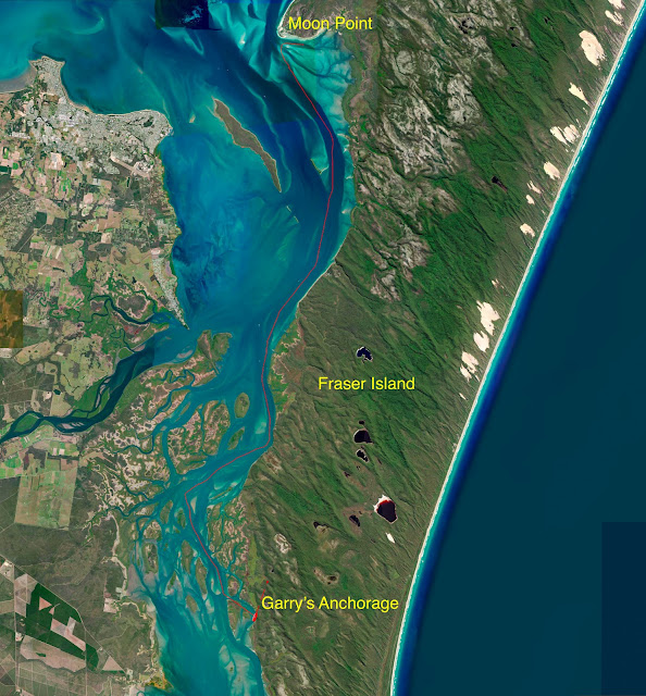
Next leg a fast run down to Bundaberg, trying to get into shelter before a strong northerly was expected. Then on to Moon Point at the southern end of Hervey Bay.

Moon Point
This is the northern end of the Great Sandy Strait, a lovely area between Fraser Island and the mainland.
Big rain forecast with thunder. We went into Tin Can Bay marina to park near boats with taller masts (to mitigate the risk getting hit by a lightning strike).

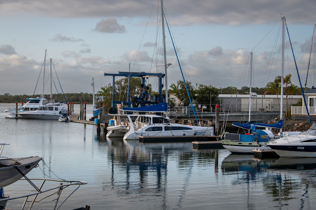
Antidote in Tin Can Bay Marina


Old trawler in Tin Can Bay

Scotty the fisherman


A lovely shore walk


Looking up into Tin Can Inlet

The Wide Bay Bar
This is the most significant hazard for cruising boats on the east coast of Australia. It is a sandy passage between the mainland and Fraser Island. The sand banks keep moving, and the channel is surrounded by shallows where waves break. See this video from 1:00.
I have been campaigning for an upgrade the nav aids at the Wide Bay Bar for several years. See these blog entries:
The good news is that the situation has now dramatically improved, using 'Virtual Buoys' being controlled by AIS. For those who are not familiar with AIS (Automatic Identification System) it is a system which is compulsory for large vessels, and increasingly common in smaller boats, whereby a VHF or satellite signal sends out location and other information that can be displayed on a chart-plotter. The signal can be tweaked. Thus instead of a signal essentially saying 'I am here', it can be made to show a sign 'Imagine there is a green mark there'.
These can be moved whenever a new survey suggests that the sand banks have moved.

The WB 1-5 marks can be seen on the chartplotter on a vessel with AIS.

Virtual buoys seen on the chartplotter
A short video of our crossing. Top of the tide. Not too hard.
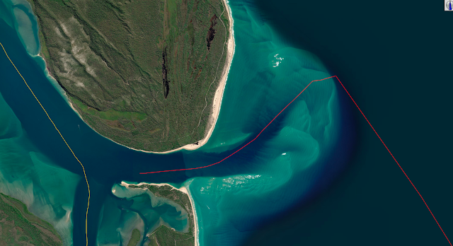
The track we took.
From the Wide Bay Bar to Mooloolaba, where we met up with old friends Helen and James.

Mooloolaba is a watersport town. These are 'nippers' on a training run around the river.
Then a fast sail on to Tangalooma on Moreton Island.


A cruise ship passing Tangalooma at sunset.

The Big Sandhills on Moreton Island

Lovely patterns at low tide from the drone


Pelicans

Jumpinpin
